 |
| Looking out over Pratt Lake - photo courtesy of HIWalker Photo |
Our original plan this day had been to hike the trail to the summit of Dog Mountain, a 9 mile trek with roughly 3800 feet of elevation gain. It's an abandoned trail, so we made a pit stop at the Ranger station in North Bend to glean what information we could and to purchase the necessary maps. What we learned is the road out to that entire wilderness area is impassible ... unless you have a (very) high clearance vehicle, which my Mustang is not. He recommended, as an alternative, the trail out to Pratt Lake which is 11 miles round trip.
 The Pratt Lake trail shares a trailhead with the route to Granite Mountain, which we hiked a few weeks ago. We shared the trail for the first mile, then split off onto our own adventure, while the majority of our fellow hikers headed up to the lookout. The first leg of our hike was on a nicely maintained trail with moderate elevation gain. A few of the puncheons (foot bridges) are beginning to show signs of decay, but the WTA has had work parties out on this trail stripping cedar logs in preparation for replacing them. The dedication of volunteers to the maintenance of our state's trails is beyond compare.
  The higher we climbed, the more the colors of the foliage changed, reminding us that we were hiking in that spectacular season known as autumn. I breathed deeply, partly because I was almost out of breath, but also to take in the aroma of the forest. The mosses, trees, stream beds and forest floor all add aromatic tones to an olfactory symphony that just can't be described. We stopped at the junction with the Olallie Lake trail, where we enjoyed a moment's respite and a quick bite to eat.
 Eventually we reached the ridgetop, where we had views of Olallie Lake below us, as well as our first peek at Pratt Lake. The evergreens here were adorned in cloaks of lacy Spanish moss, which made them look as if covered in hair, and the maples showing their autumn color. We met a pair of older hikers, in their mid-seventies, who have been hiking together since their boy scout days. They regaled us with tales of hiking in the old days before bidding us adieu as we parted ways.
 |
| Olallie Lake |
We finally made it to the shores of the lake, where we enjoyed a delicious lunch. There's just something about hiking in the woods that makes food taste better. We spent a full hour there, soaking tired feet in the icy coolness of the lake, taking photos of the astounding scenery. The only way it could have been more remarkable would have been to have blue skies. You'll not hear me complain though, as the milder weather meant no bugs.
We spent an hour at the lake before cleaning up, making sure to leave no trace, and donning our packs for the return trip.
 |
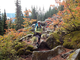
| Heidi and Zillah climbing the boulder field |
Looking back, I am very pleased with how well I did on this trail. The elevation was less than what I was hoping for, but at eleven miles, this was the longest trail I've done yet. We were on the trail eight hours (not counting the hour for lunch), which means our pace was faster than it has been all year. Due to the gradual elevation of this trail, I really didn't struggle much with either ascent or descent. Looking back over my year, I can see that I have come a long way in my conditioning. Have I come far enough for Mt St Helens? Only that trip will tell.
Distance hiked: 11.0 miles
Elevation gained: 2300 ft
Max elevation achieved: 4100 ft


No comments:
Post a Comment