Wednesday, August 31, 2016

Davis Peak

August 6, 2016


If I were pressed to find one word to describe our hike up Davis Peak, it would be Amazing.

We are 28 weeks into our conditioning, with Mount St Helens just two weeks off. Looking back on my own conditioning, I feel as though I have come even further than I had last year. Even though I still experience problems related to my twisted femurs and curved spine, I feel amazing. Empowered. However, when I look at how far the other hikers in our group have come, I am humbled. THEY are the truly amazing ones. When we began this journey 28 weeks ago, most were novices. A few had less than a half dozen hikes under their belts. This motley crew of hikers has successfully tackled trails that are rated 'difficult', 'challenging' and 'expert'. I have watched them build their strength, endurance, and skills, pushing beyond comfort zones. Most importantly, I have seen them pull together as a tight-knit group. Amazing.


The trail up to Davis Peak steeply climbs up not one, but two ridges to the site of a former lookout. We started out crossing the Cle Elum River, then wandered for a short distance through the forest before the trail started it's unrelenting climb. The forests on the east side of the Cascades have a different feel and smell from their westside cousins and to be able to experience hiking in these unique and varying types of forest is amazing.


The trail carried us through two miles of the burn zone of a 2006 forest fire, ignited by a lightning strike, which scorched 900 acres. To see firsthand the magnificent touch of God's hand as He helps the forest rebuild after tragedy is awe-inspiring. Even more incredible was to be standing there, staring out over the burn zone and see one survivor, standing alone, surrounded by the skeletons of its neighbors who weren't so fortunate. The floor is green with small shrubs and brush, laying down a layer of peat and offering cooling shade for new seedlings to take root. Draw a deep breath here and you smell the lingering smell of char and dried earth, but also, of all things, cinnamon. The resilience of nature is amazing. 


Heidi gazes toward Mt Rainier
We made it to the top of the first ridge where we faced one of the false summits of Davis Peak. Down below us was Lake Cle Elum, which shrank as our elevation increased. The scenery was forested and green, with the black/silver scarred path of the fire clearly evident. Mount Rainier and Oregon's Mount Hood were visible to the south. To the north we could see the zigzag ridgeline of Davis Peak and the valley it created. We could just discern the actual peak itself. We sat amongst the boulders here and had a quick bite to refuel for the next leg of our journey, surrounded by all this beauty. Amazing.


From the first ridge we dropped down a short way into the valley, traversing the ridge and crossing a small boulder field, then zig-zagged our way up the opposite ridge face. There are times I hate switchbacks. This was not one of those times, as we ascended from 5600 to 6400 feet of elevation is short order. To have done so without switchbacks would have been grueling. When we crested the second ridge, we arrived at the location where the fire lookout once stood. It has long since been dismantled and removed. In its place hikers have created a memorial of sorts - a structure built entirely of well placed stones. It was an amazing sight to behold. 
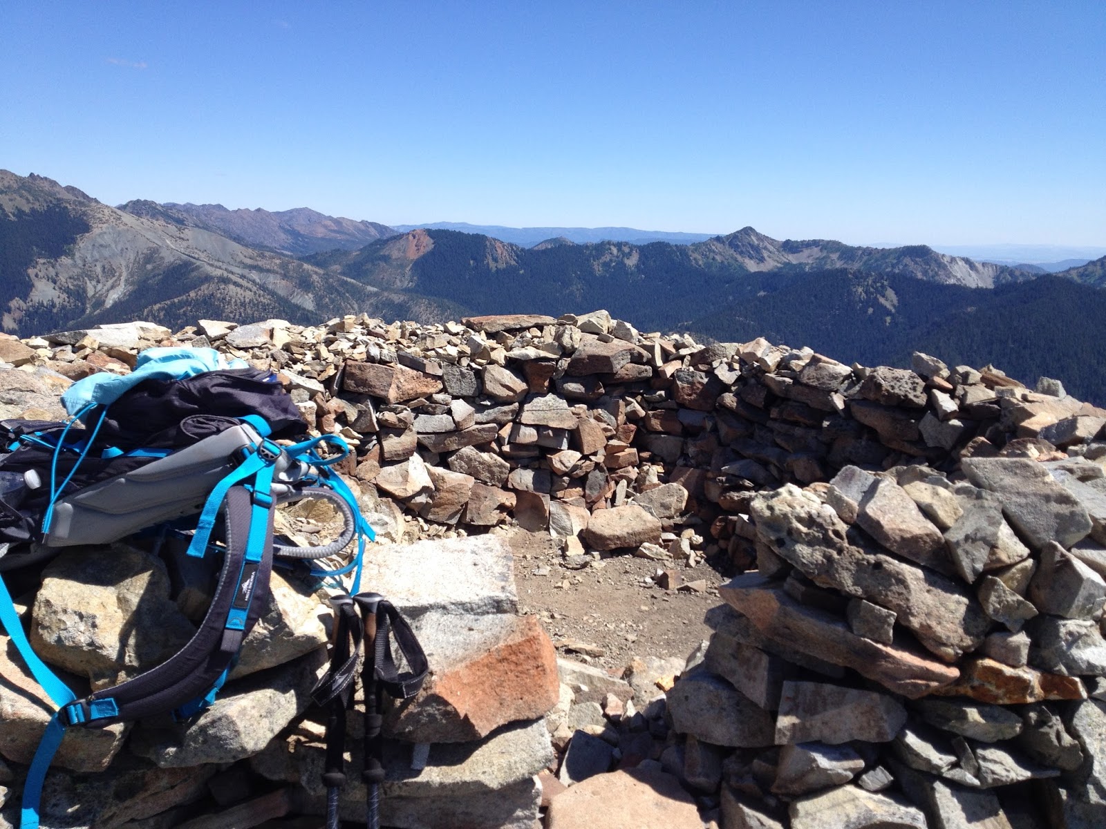
The summit of Davis Peak
The true summit, as well as another false summit, lay just a short half mile down the trail. To one side of us the mountain was lightly adorned in summer green. The other side was the reds and browns one would expect to find in a desert canyon. The contrasting scenery was breathtakingly amazing. Before us the summit loomed, an ominous dark gray in color. The scramble to the top was too sketchy and technical for most of those in our group, but a few braved it. The remainder of us were happy with the false summit upon which we perched. 

We enjoyed lunch and a well-deserved rest within the stone walls of the former lookout. Had a healthy wind been blowing, the walls would have provided us protection. As it was, the summer sun beat down on us and its heat radiated back at us from our walled enclosure. It was then we realized we were basically sitting in a kiln, slowly being baked from all sides. Not wanting to become little hiker raisins, we packed up and headed back down the trail. 

It was on the return trip that I witnessed the cohesiveness of our amazing group come into being. Evie began seriously struggling, experiencing significant and worsening pain in the back of her knee. Every step down the trail was progressively more agonizing. Being the amazing woman that she is, she did her best to keep up but began falling further and further behind. Even though it hurt him to do so, Bill hung back with her to make sure she was going to be okay. At about the half way point the rest of us stopped to wait for them. When we realized how much pain Evie was in, Heidi took her pack from her, proceeding down the trail carrying twice the load. We all maintained Evie's pace, encouraging and supporting her. Another half mile down the trail, we sent the men on ahead, since the slower pace was physically difficult for them. About a mile out from the car, Tony returned, carrying freshly filtered water. After everyone refilled their supply, he took Evie's pack from Heidi. Heidi and Lisa returned to the cars with him while I stayed behind with Evie. Every step she took was accompanied by a silent wince, as the condition of her knee continued to worsen. We began losing daylight as the sun crept below the surrounding peaks and ridges. Next thing we know, here comes Heidi with headlamps so we could safely see the trail.

Once we arrived at the trailhead, we were surprised to find our after-hike clothes and shoes laid out for us. Snacks were waiting, as wer water and electrolytes. Evie was helped out of her boots and into the car. 

Although the day didn't end on a positive note, the journey itself was an amazing one. The weather and scenery were amazing. To experience the camaraderie that hikers share was amazing. Yes, the adventure to Davis Peak can best be summed up as Amazing.

*As a side note: Evie strained her hamstring. She followed her doctor's prescribed treatment and was healed enough to join us for the trip up Mt St Helens two weeks later.

At the Cle Elum River
Hike 41 of 52
Distance: 10 miles
Elevation Gain: 4000'
Highest elevation achieved: 6400'

Friday, August 12, 2016

Carne Mountain

July 30, 2016

The trail to Carne Mountain (pronounced "Karn") was another one that I nervously looked forward to. Admittedly, I was ready to turn around and go home before we were 1/4 of the way up the trail. Not because of the difficulty, mind you, but because there were enough trees down across the trail to make it not fun. Since there are other more popular trails in the area, this one doesn't get hiked as frequently, therefore it falls lower on trail maintenance radars. Other than the dozen or so trees we had to climb over/under, the terrain was even and the trail in good repair. Good trail conditions can make a difficult hike easier, and vice versa. I set my anxiety aside, pulled on my big-girl panties, and faced my most difficult hike to date.  


My hiking partner this week was my younger sister, Heidi, also an avid hiker. I always enjoy hiking with her. Unfortunately our paths don't often intersect, but all the planets in the cosmos aligned just right for us to share a few hikes together before St Helens. Our adventure began before we even reached the trailhead - the road out to the trailhead got 'interesting' in places, and we laughed the laugh of sisters as she deftly navigated every bump, drift and rock in her little Saturn. I'm here to tell ya, that company knew how to build one tough little car. When we arrived at the parking lot I learned that, although our trail isn't heavily hiked, the trail that shares the trailhead is. There were easily 3 dozen cars in the lot and more lining the side of the road, tucked into the brush and trees. We found a spot on the road, parked, donned our packs, and began our trek.

The trail starts out flat and wide for the first hundred yards or so, until you reach the spur trail for Carne Mtn. From there the trail starts a steady, steep climb through a forest of beautiful fir, hemlock and cedar. The trees grow taller and thinner on the east side of the Cascades than on the west, due to the drier climate, which give a different feel to the forest. The air was warm and the smells were divine. It wasn't long before we came to the first of many trees down across the trail - there were over a dozen in the next mile, and some fell in clusters (one tree taking out its neighbors as it fell). We made our way over, under and around each obstacle as we came upon them, noting that some of these trees had been down more than a year.

Heidi demonstrates how to navigate a downed tree like a diva
Trailside Blueberries (photo by Heidi Walker)
Once we made it past the majority of the fallen trees, my sister started experiencing the labored breathing that has been plaguing her all year. I was thankful that it was just the two of us, as we were able to slow down our pace and take more frequent rest breaks without feeling like we were burdening anyone else. The plus side to assuming a slower pace - we had time to graze on all the ripe wild blueberries that lined the trail! The rest breaks came at a cost, however ... the biting black flies were out in force and, as we fed on the blueberries, the flies fed on us. I felt like a goat being herded along by those little jerks nipping at our heels - I have almost two dozen bites on the backs of my legs! Anybody who knows me, knows I wasn't using my polite words...

As we slowly and haltingly made our way up the mountainside, we were treated to increasingly better views of the surrounding peaks and ridges. The sun kissed our faces and a cooling breeze would blow up from the valley. We could hear the Chiwawa River below us as it made its way to join the Wenatchee. Eventually even that voice faded to obscurity as we climbed into the solitude above the tree line where the only sound was that of the wind as it carried off our voices, the occasional clicking of a grasshopper in flight, ... and the stupid flies. After about 3 miles we came to blessedly cool thicket of trees in the shadow of an unidentified peak and facing a rugged waterfall. I left Heidi here to rest while I investigated the trail up ahead. I needed to see how strenuous the remainder of the trail was and calculate our location. This way we could make the decision to push on to the summit or turn around. Although not yet at the summit, the view was beautiful. I caught sight of the larches for which this area is best known, and was humbled by the vastness of the mountainous vista that stretched out before me.


Once I reported trail conditions and status back to Heidi, we decided to call it a lovely mountain hike rather than a summit trip, and we headed back down to the trailhead. The winds had picked up and the sun shifted, casting the majority of the trail in shade. With the cooler temperature, the flies retreated to wherever it is that they go when they aren't devouring hikers. (I'm thinking they return to hell) We stopped mid-trail to eat our lunches, supplemented by another few handfuls of blueberries. By the time we made it back to the obstacle course of trees, Heidi was feeling better and our usual light-hearted banter and girlish giggles resumed. As children we didn't always get along - our mother used to foretell of a day when we would be best friends. I'm so very glad her prophecy came true! 

We didn't make it to the summit of Carne Mountain this trip and I'm okay with that. My sister's health is far more important. The summit isn't going anywhere. We plan on returning this fall for an overnight pack trip, camping near where Heidi awaited me on the trail. We will venture from there to the summit. The summit is supposed to offer fantastic views that will be further enhanced by the spectacular golden hues of the turning larch. I look forward to returning and spending the night under the stars and in the shadow of the mountain with my sister.


Hike 40 of 52
Distance: 6 miles
Elevation Gain: 2395'
Max Elevation Achieved: 5840 ft


Tuesday, August 2, 2016

Green Mountain

July 23, 2016

There is a historical lookout perched atop the summit of Green Mountain that has been the topic of a legal battle, pitting the wilderness preservationists against the historical preservationists. After a recent restoration project, it looked like it was going to have to be dismantled and removed. Finally a settlement was reached and it was allowed to stay via an act of Congress and signature by President Obama. The lookout has on the National Register of Historic Places since 1987, and it is a popular destination. However, the Park Service had permanently closed it to protect it from vandals. Sadly, these idiots exist even on the tops of mountains. I love our historical fire lookouts and visiting this one has been a desire of mine for a few years.

Green Mountain is located in the North-Central Cascades outside of Darrington. It's a busy trail, so we arrived at the trailhead in time to hit the trail at 9am. There were already a dozen cars there, so we knew we would have a little company. For the third week in a row, we were starting off in heavy cloud-cover which we were, of course, hoping would burn off before we reached the summit.

Elbow deep in foliage
Considering the amount of foot traffic this trail sees, it was in GREAT condition! It started out immediately climbing with moderately difficult gain, steadily carrying us up 1600 feet of elevation in roughly 2.5 miles. We hiked through beautiful forest and along the face of the ridge where the thick vegetation grew 3-4 feet tall. The cloud cover stayed with us, teasing us by thinning a bit, then thickening up again, giving us only peeks at what lay beyond. 


We crested the shoulder of the mountain and looked out over a beautiful, pastoral meadow located in a bowl below the mountain. There was a picturesque tarn of crystal clear water. It's glassy surface reflected back the greens and blue-blacks of the trees and boulders of the mountainside behind it. We stood there a moment, enjoying the view. Then it came. The swarm. A cartoon swarm of mosquitos mobilized in a thick black arrow and diving straight for us. We could almost hear a miniature bugle signal their attack. They dive bombed us with a precision any modern day military air force would envy. We armed ourselves with various insect repellents, which caused our assailants to pull back momentarily, but only to re-strategize their offensive. We found that the best defense was to cut and run - so we beat a hasty departure across the meadow, seceding it to our adversaries. Even so, they sent some advance teams out who waged a singular aerial assault, stealthily landing on clothing and impaling us through the cloth. Insidious little creatures.

Having survived the swarm attack, we now faced a 1200 foot climb in just a little over a mile. The trail switch-backed up the face of the mountain, through alpine meadows, rock outcroppings and copses of dwarfed alpine trees. Up and up we climbed, higher and higher up into the clouds - which, I'd like to point out, weren't showing signs of burning off any time soon. The final 1/4 mile is along the top of the summit's arm. We had a drop-off to the right that probably offers some impressive views when not under cover of a thick cottony blanket of clouds. The presence of the clouds added a sense of mystery and suspense that you'll never experience in a movie theater - you have to get out and live it. In places you couldn't tell where a snow field ended and the clouds began.

We climbed up over the last few boulders to the summit where we were met with a most spectacular surprise .. the lookout was open! As part of a park service pilot program, a few volunteer rangers had hauled their gear up for the weekend and opened the lookout. They shared part of her history, the story of her restoration and her future plight. These volunteers stayed the entire weekend up there and would be lowering the shutters and locking her up tight when they left. How successful this program is this summer, as well as availability of trained volunteers, will determine if she is ever opened up again - so this may well have been a once-in-a-lifetime experience for us. 
Our group on the lookout; Dan, Myke, Bill, Evie and me
Marmot amongst the wildflowers
We ate our lunch then headed back down. In addition to her controversial lookout, Green Mountain is also well known for its celebrity marmot. Known as the "Greeter of Green Mountain", this marmot sits on a large, flat boulder and whistles greetings to all the hikers passing through his front yard. We got some good marmot loving from him as we followed the trail around his perch - he's a very talkative chap. A little further down the trail we encountered a large female standing tall, protecting her den. She was beautiful. A bit further down the trail, just before our earlier battlefield, we heard a Pika chattering a warning to us. I pointed her out to the others, then responded to her tirade with a resounding "Eep!, Eep Eep!". Apparently I speak Pika-ese, as she stopped screaming at us, tilted her head and responded with a singular "Eep!" then sat quietly and watched us pass. The mosquitos were busy mounting a blitzkrieg against another group of hikers, so we were able to pass with minimal trouble. From there it was smooth sailing to the trailhead.

Once back at the trailhead we celebrated a successful hike, lamented the absence of a view, and all agreed that this was a trail to be hiked again. Mosquitos be damned. I felt good after completing this trail. Green Mountain has rightfully earned a place at the top of my favorite trails list and I expect to return next year ... with stronger insect repellent.  

"Without new experiences, something inside of us sleeps. The sleeper must awaken." ~Frank Herbert


Hike 39 of 52
Distance: 8.5 miles
Elevation gain: 3300'
Highest elevation achieved: 6500


Wednesday, July 27, 2016

Mount Dickerman

July 16, 2016


This trail, although beautiful and known for its Lord-of-the-Ring type views, is not for the casual hiker. With terms like "strenuous", "steep", "stiff", "beastly", "difficult" and "expert" used to describe it, one should certainly be wary before planning a trip up Dickerman Mountain (it's official name). Oh, and if you find the trail report that calls this a "simple hike" .... ignore it. That writer is either severely delusional or possesses a very sick sense of humor.


Located in the Cascades on the Mountain Loop Highway near Granite Falls, this was a hike I had looked forward to all year. The views from the summit are quintessential and worth every ounce of sweat to attain them. Granted, I was a little nervous about this one. At over 3900 feet of gain, it was to be the steepest trail I had attempted to date ... other than Mt St Helens, of course. The forecast for the day was mixed, so I was hoping the thick (wet) cloud cover that was present when we arrived at the trailhead would burn off before we reached the summit. 


The trail started off in a forest so dense that only moss and ferns grew on the floor. The low lying clouds gave a feel of walking through fog and daylight filtered through giving the forest a ghostly atmosphere. The terrain was good for the first half mile. Switchback after switchback quickly carried us up through a changing forest, the trail becoming steeper and rougher as we climbed, the trees thinning and shorter-growing the higher we went. Along this first third of the trail you could see evidence of recent trail maintenance projects, and we appreciated the efforts of those WTA volunteers.

Slowly and gradually we made our way up the mountain, the scenery around us changing with every few hundred feet we climbed. We stopped occasionally to appreciate the beauty surrounding us and to catch our breath, our lungs and hearts working overtime to supply oxygen to our muscles.


At about the halfway point we encountered a rockslide that totally blocked the trail with boulders. There was a tall ribbon waterfall there that was so pretty but nearly impossible to photograph due to the boulders. With great care we made our way around/over the obstruction. At this point we were told by other hikers we only had 1.25 miles left to go. What a relief! That relief, however, was short lived as the real "fun" still lay ahead.
Maple shaded boulders
We popped up out of the forest into the prettiest meadow that was chock full of beautiful mountain heather and wildflowers aplenty, mosses and young vine maple. A small stream wound its way around the boulders, forming crystal clear pools and tiny cascading waterfalls. It was peacefully serene beyond words and we drank it all in, replenishing our souls.

From there the trail got down to some serious business. The elevation increased significantly, as did the trail erosion. Apparently recent maintenance projects stopped prior to the meadow. We were walking in boot trenches that were 5 to 9 inches deep (which is hard on the hips), navigating a tangled web of exposed roots, stepping up over wooden steps where the surrounding soil (above, below & behind) had totally eroded away, and maneuvering around sizeable rocks, trying not to roll our ankles. We had reached a veritable trail hell. We encountered hikers on their way down that told us we were only 1.25 miles from the summit. Wait. What???

We eventually made it to the top. I'm sure that ultimate view we had worked so hard to take in is breathtaking. For us, the summit was socked in with visibility of about 200 feet. We couldn't even see the other point of the peak. We were able to gaze down the cliff side, which drops 450' straight down. That in of itself was remarkable. We found ourselves a suitable chunk of granite and sat down to eat lunch. The summit is fairly good sized so, although other hikers joined us, there was plenty of room for all and, due to the heavy clouds, we felt somewhat isolated.


Drop-off to Nowhere


Once lunch was done, it was time to head back. If the final leg of the ascent was tough on the way up, it was an absolute nightmare on the way down. With every step we felt the strain on our ankles, knees, quads and hips. By the time we reached the trailhead, my legs were like spaghetti. After sitting a few moments at a picnic table, I got up with the intention of visiting the vault toilet. My legs, on the other hand, had other ideas. I must have looked hilarious doing the penguin walk all the way!


Our Group at the Summit: Holly, Andrea, Me, Evie (clockwise)

This was a challenging hike that failed to provide the promised payoff due to the weather. The trip back down the trail was far worse that the trip up due to the extreme trail erosion and resulting rough terrain. My knees actually swelled from the exertion, and stayed stiff and swollen for a week. Was the journey up Mt Dickerman worth the effort? Absolutely. Even without the view at the top, it was an experience to learn from and an opportunity to test the limitations of my body. Would I make a return trip? If you could guarantee me clear skies, you bet. They make ice for swollen knees, after all...

Crossing the Rockslide at the Waterfall
Hike 38 of 52
Phlox at the Summit
Distance: 8.6 miles
Elevation gained: 3950'
Highest elevation achieved: 5760'


**Most photos taken by Myke Moe, Andrea Cuaran or Evie Osburn


Monday, July 25, 2016

Granite Mountain

July 9, 2016

The hike to the fire lookout on Granite Mountain was a return trip for me. Some trails I enjoy returning to, partly because of their beauty and partly to double-check my level of conditioning. Granite Mountain's trail was one of those trails. Although not an easy trail, it isn't a grueling one either ... and worth revisiting occasionally.

Our trip started out with a questionable forecast. We were prepared for whatever might come our way with layers and extra clothing for the summit. We arrived at the trailhead early, eager to get our journey started. The trail started out wide, well-maintained and of moderate grade for the first 1.25 miles. There the trail splits, one direction heading to Pratt Lake, the other to our destination - Granite Mountain lookout. From this point the trail gets down to business, growing more rugged and climbing more steeply via a series switchbacks. It was littered with rocks and boulders that had to be navigated. I was surprised by the amount of trail erosion from foot-traffic since last year, making the terrain rougher. Finally we popped out above the trees and began climbing the ridge. All around us were wild blueberries and other scrubby shrubs, tufted bear grass and the now familiar lupine, paintbrush and tiger lilies. For a moment the cloud cover looked as though it might start burning off. 

At the top of the ridge is a pretty alpine meadow with a small, crystal clear pond. It was here we stopped to rest and grab a quick snack. The meadow was the deep green and bright pink of Mountain Heather. Bees buzzed around us, busily visiting one blossom after another. On a rocky outcropping overlooking the meadow, a marmot sat watching the silly humans. The lookout was visible above us, but experience told me we still had over 45 minutes to go before we'd reach it. I found the tree I had a photo taken with last year, so re-created the pose for another shot. We couldn't linger here long, however, so donned our packs again and resumed our trek. 

Here the adventure got interesting. So many people had gone off-trail in a hurry to reach the summit that the trail is difficult to follow. Fueling the difficulty was the fact there is a winter route, and a summer route; only one route shows on the maps, so it was unclear which was our trail. Add the presence of snow covering many portions of the trail to the mix, and you have the recipe for an interesting hike. We got it figured out and headed around the backside of the summit. 

Making our way to the lookout
What a difference a year makes. Last year this area was barren, just dirt and boulders. This year we had snow, mud and running water to contend with. Last year we had a jaw-dropping view of the surrounding mountains and peaks. This year we had heavy cloud-cover and limited visibility. Last year it was warm, this year there was a chill breeze blowing. Nevertheless, we continued up the trail until we finally arrived at the summit and its lookout.

Once at the summit the wind kicked up a bit, so we put on all our layers. We sat under the lookout for some protection from the elements and ate our lunches. Chipmunks and Chickadees joined us in hopes of a handout. The clouds never dissipated for us, so we headed back down. 


Our summit group: (clockwise from top)
Holly, Me, Bill, Myke, Dan & Evie
I was happy with the relative ease I was able to make the return trip. Having just come off our multi-day pack trip, I had expected to experience more difficulty with my knees and hips, especially in the rougher areas. Everyone did great on this trail, even those who struggled more with this one then they thought they would. We pushed on through everything, supporting each other like the friends we have become, and reached the summit together. I regret that we didn't have the incredible view from the top that I know exists, but the mountain will always be there to climb again should any of us decide we want to catch that view.

Adventure is the pursuit of life.  

Me, just below the summit
Hike 37:52
Distance: 8.6 miles
Elevation gain: 3800'
Highest Elevation Achieved: 5760'


Friday, July 22, 2016

July Trek; Day Five; Camp Handy to Trailhead

July 5, 2016


The final day of our five-day adventure dawned with a quiet tranquility. It was a peace that can only be experienced in the woods. I lay in my tent as long as I felt was allowable, breathing in the crisp mountain air and expelling the last vestiges of stress from my daily life. The river called to me and for a moment I felt it as it cleansed my spirit - a calm washed over me and a long eluded serenity filled my soul. Life was good.


Morning view from my tent

After our breakfast, we busied ourselves with what had become a morning routine, then donned our packs for the last time. As I walked about camp, I found an owl feather - which I took as a sign of my mother's presence. There was more laughter and chatter than there had been the past few days. Although everyone was enjoying the trip, we were all glad to be heading home where hot Epsom salt baths were calling. Well rested and energized by the knowledge that we would soon be home, we took leave of camp and headed on down the trail.  

The final leg of our journey would take us along a familiar section of the Upper Dungeness River trail out to the trailhead. This was the perfect trail on which to finish our journey. With only 600 ft of elevation to descend, all in lush old-growth forest, it felt like a simple stroll through the woods. Our weary bodies appreciated the easier terrain and lighter pace of the day. We rambled past Dogwood (Bunchberry), blossoming Thimbleberries and lush ferns growing along the nearby river.

Oh, and the river! It was, in a word, resplendent. Always one to impress, the Upper Dungeness didn't disappoint. The trail carried us along its banks, where we were treated again and again to its beauty. It bounced and tumbled over the boulders in its bed, crystal clear in places, and turquoise blue in others. We crossed it twice on log footbridges and the dogs were such pros now they didn't falter or pause in their crossing. The weather threatened rain, but there under the forest canopy we felt only an occasional drop come through. It was a relaxing hike.


Before we knew it we had arrived at the trailhead. From there it was a short walk to the parking area where we had left our car ... and the vault toilet. It truly is the little things that bring us joy.

We had survived. This was my longest backpack trip, and it was Evie's first. Although I had labored under the weight of my pack, I can't say I ever truly struggled. My hips, knees and back ached at each day's end, but had held up to the load and served me well. Looking back over our journey we can feel pride in our accomplishments. We had ventured outside of comfort zones, tested skills, rallied against physical limitations and pushed beyond endurance levels. We stared in awe at glorious peaks and ridges, marveled at massive old growth trees and come face-to-face with mountain goats. We crossed snow fields, trekked across alpine meadows and climbed a mountain. We found peace, strength and friendship.

"Climb the Mountains and get their good tidings.
Nature's peace will flow into you as sunshine flows into trees."  - John Muir


All packed and ready to hit the trail
Hike 35:52
Distance 3.2 miles
Elevation Gain (Loss): -600'


Thursday, July 21, 2016

July Trek; Day Four; Boulder Camp to Camp Handy

July 4, 2016 - Independence Day.
 
The previous day's decision push to on Boulder Camp meant that we were two miles closer to our day four destination - Camp Handy. We were able to linger longer in our tents, and lounge a bit at camp. The sun lit up the peaks that formed a sheltering ring around camp, with Mt Buckhorn staring down on us from the northeast. It was amazing to think that we had not only been on the other side the previous morning, but that we had come over the top of his western leg. Having recovered from the exertion of the day before, I was filled anew with a sense of accomplishment.
Daybreak at Boulder Camp - Photo by HIWalker Photo

Looking back, I find it fascinating how quickly our mornings had become routine in so short a time. We awoke, prepared and ate breakfast, filtered our day's water, broke camp and headed back out on the trail, ensuring we had left no trace of our stay behind - all with a casual normalcy.

Our day's journey carried us out of the bowl where Boulder Camp and further down the western side of the ridge we had spent two days traversing and climbing. As we hiked, the terrain gradually descended and the severity of our surroundings softened. The trees began to grow taller and thicker as we left the subalpine forest behind us, bathing us in welcome shade and shadows. The alpine wildflowers of our previous three days were replaced now by shade-loving Candystick, Bog Orchids, Wintergreens and delicate Twin Flower. Less than two hours after leaving Boulder Camp, we arrived at Camp Handy.


 Camp Handy is another of the Adirondack style shelters constructed in the Olympic mountains during the early 1900's. There are only a handful of the original shelters remaining and, due to wilderness preservation efforts, are slowly dying out. The battle to save them has pit historic preservationists against (extreme) wilderness preservationists. Its a sensitive topic and I can see the points of the opposing views. That said, as a hiker and backpacker, I am extremely thankful for the shelters that still stand.
View of the Dungeness River from one of the sites at Camp Handy
Camp Handy is situated a few hundred feet off the Dungeness River, surrounded on three sides by forest and on the fourth by a beautiful river meadow full of Larkspur, Cow Parsnip, Twin Berry, Nettles and Salmonberry, to name but a few. We had hiked to this location earlier in the year when there was still snow covering portions of this same meadow. It looked so different adorned in a quilt of summertime color!  
We had the camp to ourselves, so found a suitable campsite then gathered wood for a relaxing and warming fire. The dogs stretched out in the sunshine for a lengthy snooze. With the most difficult portions of our trip behind us, we were able to relax  and the laughter came more easily. We reminisced over our trip thus far, shared stories about past hikes, and talked about our desires for future adventures. Dinner was delicious, and Evie brought out dehydrated Crème Brulee for a drool-worthy dessert. 


Holly demonstrates her tried & true method for breaking firewood
(photo by HIWalker Photo)
We watched the flames begin to die down in our fire as the daylight began fading. A light mist moved in, condensing over the river and filling the meadow with a peaceful quiet, broken only by the sounds of the Dungeness. The rigors of the past four days finally overtook us and we headed for our tents and the comfort of our sleeping bags. Another fabulous day on the trail behind us.


Evening at Camp Handy - Photo by HIWalker Photo

Hike 35 of 52
Distance: 3.6 miles
Elevation Gain (Loss): -1800'