Tuesday, November 22, 2016

Lake Sylvia

November 6, 2016


When looking for a pretty, low-land hike for autumn, don't discount Lake Sylvia State Park. This is the second time I've visited the park, the first being via kayak a few Thanksgivings ago. There is a trail that wraps around the lake, hugging the shoreline and offering water views, autumn colors, and, if you're lucky, some waterfowl taking a break on their journey south.
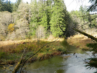


My cousin's granddaughter wanted my sister to shoot her senior portraits, and the venue chosen was Lake Sylvia. I tagged along as my sister's assistant, looking forward to spending time with family and hiking the loop trail. The forecast was calling for mostly cloudy which, as any true Northwestern resident knows, could mean just about anything goes. Nevertheless, we threw on our jackets, grabbed Heidi's photo gear and headed outside. We hit a rain squall on the way, but the weather broke and looked promising by the time everyone arrived, so off we headed.


Not in a big hurry, we followed the trail at a more leisurely pace, which was nice. There are benches placed along the trail where visitors can sit to enjoy the serenity, soak in the colors or do a little bird-watching. We took pause at a few where the setting & lighting was perfect for portrait shots. The colors, though waning, were remarkable, matched in beauty only by the subject of the portraits. I carried a deflector shield with me and had fun bouncing light off things as we walked. The rain-swollen lake spilled over its banks, flooding a few hundred feet of trail with 6 inches or so of water. Our family isn't easily dissuaded, so we rolled up our pant legs and splashed our way through. Our feet may have been soaked, but we were having fun!

As the trail wrapped around the end of the lake, we encountered our only elevation gain - the trail quickly climbed about 3 stories. Just before dropping again and delivering us back to the lakeshore, we were treated to an adorable covered bridge spanning a small stream. Heidi shot a series of photos here, giving the rest of us time to more thoroughly appreciate the beauty of our surroundings. Autumn yellows, golds and browns blended with the darkness of the evergreens, standing in contrast to the deep blue of the lake. As I leaned against the railing, gazing out through the trees,  a small flock of Canadian Geese broke the glassy surface of the water as they swam past. Above us, birds chittered and flitted about. Below us a plethora of fungi grew profusely. It was enchanting.


Another stop was made at a picturesque location on the bank of the lake where a few more shots were taken, then we finished our day back at our cars.


I always enjoy watching my sister work, especially when it means time can be shared on the trail. We were blessed with good weather on a weekend with a stormy forecast, and the opportunity to spend time with family ... and Lake Sylvia was the perfect host.


Challenge Hike 52 of 52.
Distance: 5 miles
Elevation gain: 30'
Max Elevation Achieved: 170'


Friday, November 11, 2016

Iron Goat Trail

October 30, 2016


Tunnels of Terror. Who can resist a trail with a history that includes that phrase? Certainly not me!


The Iron Goat Trail was so named as it was once part of the Great Northern railway over Stevens Pass - and their logo was the mountain goat. This section of rail was considered, at the time of its construction in 1893, the best engineered of the transcontinental railroads. Seattle had just celebrated its 40th birthday, and was now connected to the Midwest by rail, providing a faster method to transport its main export - lumber. Trains struggled over the steep route, which required locomotives at each end of the train to climb the grade and negotiate the sharp turns. During the winters, snow 25 feet deep would immobilize the trains for days while dozens of laborers wielding shovels dug them out. In 1900 a 2.6 mile long tunnel was completed, as well as a series of snowsheds which somewhat helped. However, in March of 1910, a huge avalanche of heavy, wet snow came barreling down the mountainside. Two trains were waiting outside the small community of Wellington for the tracks to be cleared of snow and were swept up by the avalanche. All 97 people aboard were killed; the snows were so heavy that year that the last body wasn't recovered until July. The costs of constant maintenance and downtime of the trains was insurmountable - Great Northern finally gave up and built a 7.8 mile tunnel beneath Stevens Pass, which is still used today. In 1929, just 36 years after it was built, the old tracks were abandoned.


Work began in the 80's to restore the grade, and construction of a trail began in 1992. Built primarily by volunteers working weekends, it wasn't completed until 2007. The Iron Goat Trail is well built and well maintained, with many sections ADA accessible. All along the way there are the old tunnels and the concrete support walls of the snowsheds, the wood structures of which having long ago collapsed and/or been removed. There are interpretive signs placed along the route pointing out historical facts and natural points of interest. It has long been on my bucket list and, knowing its tragic history, I thought Halloween weekend was as good a time as any to hike it. My sister Heidi, and friends Andrea and Annelise (also sisters) joined me.


Timber Spillway
It was raining the day we chose to hike the Iron Goat Trail, which added to the ominous air of the route. As we hiked along the wide, mostly flat trail through the forest, we could hear the sounds of nearby trains making their journey across the pass. The fact we couldn't see them, only heard their sounds echo off the walls of the nearby ridges and peaks, made them seem like ghosts. It was hauntingly eerie. Ground water gushed over the edges of the snowshed walls, creating waterfalls.  That lumber of a spillway remains, with water freely flowing over it, fueling the decay that will someday devour it. Back in 1893, this spillway was the  pride of the railway, which was part of their firefighting system.The tunnels are collapsing and entering them is dangerous. Should you dare to venture in a few yards, however, you are immediately surrounded by absolute silence. From time to time we would encounter large pieces of steel left behind, their previous function a mystery.

Steep section of trail to the upper trail
There are three trailheads to access the Iron Goat Trail and multiple choices of route, which means you can choose the length and difficulty of your hike. We started at the Martin Creek trailhead and hiked to the trailhead at the other end (where there is a potty). From there we took the Corea Crossover, named for the small railway community that was once located here. This crossover led us via a steep climb to the upper trail. It was hard to imagine a train having to chug up that same 700' incline. Granted, they had steam and I only had two skinny legs, but I weigh a whole lot less. Under either scenario it was still a grunting ascent. From there we continued on a spur trail to Windy Point. We were buffeted by driving rain and gusts of wind. The valley below us was filled with misty clouds. Somewhere down there we could hear the sounds of another distant train travelling unseen. As it passed, its sound was replaced by that of a large waterfall that could be seen on the opposite side of the pass. We were at risk of losing daylight on our return, so we didn't travel the 3 additional miles out to Wellington and the site of the disaster. We'll save that visit for another trip.


Danger still exists along this long-abandoned railway. A few years ago a 15-ft tall avalanche let loose, demolishing a bridge and burying a large portion of trail. Had anyone been on the trail (which isn't advised after snows begin falling), their souls would have joined the 97 that still haunt the area.


Hike 51 of 52
Distance: 6 miles
Elevation gain: 700'
Max elevation achieved: 2,800ft

 
Rugged Gnarly Women; Me, Heidi, Andrea & Annelise

Monday, November 7, 2016

Fort Casey / Admiralty Head Lighthouse

October 29, 2016


Anyone who grew up in Western Washington during the 60's and 70's likely has fond memories of visiting Fort Casey in the sixth grade. We would packed our suitcases and headed to the enlisted barracks, now called Camp Casey, for an overnight field trip as part of our Washington History course of study.

Fort Casey, along with its siblings, Forts Flagler & Warden, has great historical significance in the Pacific Northwest. They were shortly built after the Spanish-American War to protect Admiralty Inlet, and subsequently Puget Sound, from attack or invasion by sea. They were armed with 10-inch guns on disappearing carriages, which would raise from their protective emplacements long enough to fire, then recoil back down out of sight. However, by the time construction was complete, the forts were obsolete due to the introduction of aircraft to the military arsenal. Fort Casey was utilized as a training facility in WWI and WWII, decommissioned in the 1950's, and sold to Seattle Pacific University. The forts are a wonder to visit. I have returned dozens of times in the years since sixth grade to explore and marvel. No matter how many times I visit, or how old I get, Fort Casey still brings out the little girl in me.


Most people just visit the fort batteries where the guns reside. Many also walk up the hill to visit (and maybe tour) the Admiralty Head Lighthouse. Few, however, venture to follow the trail down to the old storage bunkers, which are built into the hillside. Even fewer wander down the hill to the beach, from where you can view the platforms that once housed big searchlights. Although more of a stroll than a hike, if you plan your adventure right, you can link everything together in a big loop that includes woods, nature (deer) and pretty sights. 


This particular Halloween weekend my sister was part of a group who were haunting the fort. I was in the mood for a good scare and couldn't think of a better reason to re-visit one of my favorite haunts. My co-worker, Corinne, and her friend Tim had never been to the fort, so they joined me for this Halloween adventure. I bundled up for the weather and started my adventure aboard a ferry bound for Whidbey Island. 


I met up with my sister, Corinne & Tim in Coupeville where we had lunch. We wandered the small shops along the waterfront, taking in the historical buildings and marvelous smells wafting from the doorways of the small eateries. These aromas mixed with the sea air for an olfactory treat that can only be described as heavenly. From there it was a short drive to the Fort Casey State Park. We left from the lower parking lot and walked up the grassy knoll to the lighthouse.


The Admiralty Head Lighthouse was originally built in 1856, moved in 1897 and replaced. The current lighthouse has stood in its this location since 1901. With ships' power moving from air to steam, the marine traffic lane shifted more to the western slopes of the inlet. Thus, just 19 years into her service, the Admiralty Head Lighthouse was extinguished. At the time of its construction, it was considered one-of-a-kind as it was of stucco construction and 'fully modernized' housing both an indoor bathroom and laundry room. It's sturdy construction has helped it survive the forces of nature for over a century. It is lovingly preserved, maintained and cared for by a volunteer force of 'friends'. These volunteers keep it open for visitors to tour, and are always happy to answer questions about the lighthouse and its neighbor, Fort Casey. Unfortunately, due to the Halloween event being held at the fort, they had closed the doors of the lighthouse early. I was disappointed that Corinne and Tim weren't able to climb the tower and gaze out the windows of the Fresnel housing across the inlet and into the Straight of Juan de Fuca.


The next leg of our adventure was the fort and its guns. We headed back down the hill to the cement walls of the fort, climbing the stairs up to the emplacements. We ran our hands along the walls, the ammo carriers and the guns themselves. The fort may be a sight to see, but you can actually feel the history under your fingers if you take the time. The craftsmanship that went into pouring the walls and mounting the heavy iron & steel hardware can best be appreciated by both looking and feeling. We wandered the length of the structure, exploring rooms and lookout towers as we went, then followed the route taken by the soldiers to the storage bunkers. We entered two of the bunkers, walking from end-to-end in total darkness. Our footsteps echoed against the cement walls, fueling the eeriness. I was thrilled that a compartment was open that hasn't been in my past visits ... we were standing in one of the enlisted waterclosets (toilet). On the floor were the remaining signs of the two commodes that once stood there, as well as a urinal on the wall. There was no sink for handwashing. Privacy was afforded by wood partitions, the hand-crafted outer framework of which remained, worn smooth and stained a dark brown by time, water, and visitors' hands. Tim walked into one of the guardhouses, which looked upon both the bunkers and out over 'Crocket's Lake'. If I'm correct, this shallow body of water is where the ferry from Port Townsend now docks. 
Taking aim along one of the 10-inch guns
 
View from one of the Lookouts


We continued on our journey, winding back around and up the hill, returning to the Lighthouse. The sun was beginning to set. I took the opportunity to shoot a photo, then we headed back down to the fort to partake in the 'Haunted Fort' event.


After playing some kid's games, eating some awesome cotton candy and having the bejeebees scared out of ourselves in the fort, it was time to call it a day. The volunteers did a fabulous job haunting the facility and I look forward to returning. As we crossed the field some very ominous and creepy music was being broadcast. We looked up to see a line of cars proceeding slowly down the hill ...


Well played, Fort Casey. You transported me back to sixth grade and left an everlasting impression on me yet again.


Hike 50 of 52.
Distance: 3.5 miles
Elevation Gain: 150'
Highest Elevation achieved: 200'